Trusted by GIS professionals around the world.
VERSION 25.1
Recent Developments in Global Mapper
For nearly three decades, Global Mapper's development has depended on direct interaction with users and most of the major functional requirements can be clearly traced to individual requests. This unique approach to software development has ensured that the application is continually updated and improved to ensure it is meeting the needs of today's GIS professionals.
Developed for both GIS professionals and map enthusiasts, Global Mapper® has all the functionality you need in a GIS software.

No add-ons or additional licenses needed for the support of over 300 file formats covering vector, raster, elevation, and point cloud data types in Global Mapper. Supporting virtually all types of geospatial data for import, and nearly as many formats for export, Global Mapper users can load, combine, crop, and tile almost any data they encounter. With new and modified formats being added on an ongoing basis, you can be sure that the software will never be out of date with your data.
In addition to loading data from local files of connected special databases, streamed online data is available through Global Mapper with a wealth of built-in direct links to many of these data services including aerial imagery, worldwide elevation data, topographic maps, Landsat satellite imagery, land cover data, aviation charts, and much more. Furthermore, if a local agency or organization develops a Web Mapping Service, a custom link to this data can be easily added to the online data source list as a custom online source.
With local, database, or online data loaded into Global Mapper, the map view projection can be altered to reproject the data layers regardless of the data’s native projection. With dozens of projections included in Global Mapper entire datasets are easy to reproject and exported files are written out using the current display projection. For advanced projection and transformation management, Geographic Calculator can be utilized with Global Mapper providing access to the industry leading geodetic database created and maintained the Blue Marble’s Geographic Calculator software.
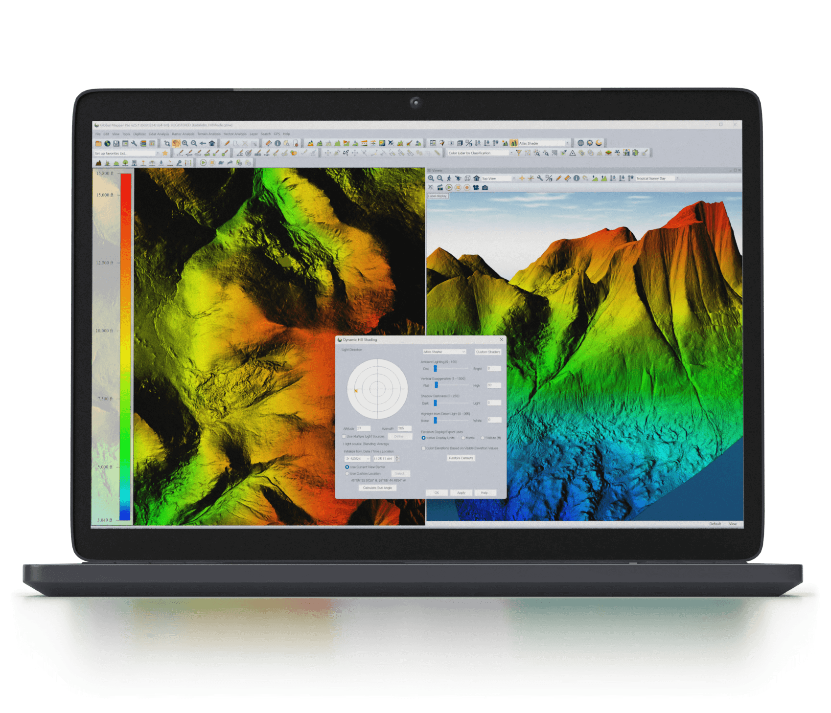
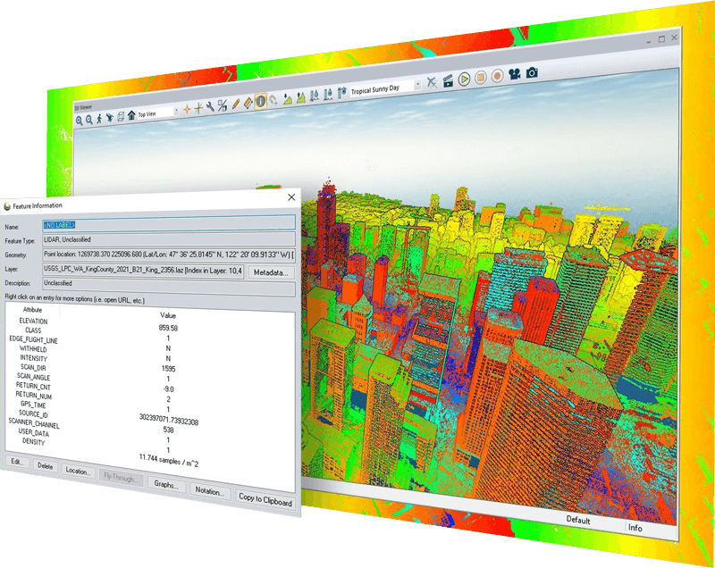
Docked windows supporting top-down 2D, oblique 3D, and cross-sectional data views can be opened, resized, and organized within the Global Mapper display for optimal viewing of any data type. When considering 3D data, configurable color-ramp shaders can be applied to inform elevation or slope values in the 2D or dynamic 3D views. Additionally, the 3D viewer supports the recording of HD fly-through videos allowing users to export a visual exploration of point cloud, elevation, draped raster data, and vector data in an easily sharable video format.
Data can be shared in any supported geospatial format as well as through screenshots, captured videos of 3D data, and static map layouts designed for PDF export or printing with Global Mapper’s layout tools. Cartographic elements such as a scale bar, compass rose, and map legend can be precisely placed within the layout frame with supplementary text and corporate branding graphics easily added to a map design that can be saved as a template for future use. For atlas or map book creation, the map layout tool offers the ability to design a tiled array of maps, in which all the pages share a consistent layout structure.
Global Mapper offers additional options for export to web tile formats creating a series of we-ready raster tiles from the currently loaded map data. These exports are compatible with common online map formats, such as Google and Bing Maps. This export process also generates an accompanying html file that is used to display the tiles within the selected format’s web interface, complete with the common map navigation and layout tools. In a partnership with MangoMap, users can also upload map data directly from Global Mapper to an online Mango-hosted map site which can be easily shared with customers, colleagues, or constituents.
Along with the unrivaled ability to import existing datasets, Global Mapper supports a wide range of digitizing tools for vector data creation. The comprehensive set of digitizer tools provides users with standard options for point, line, and polygon features as well as tools for creating specialized geometric features such as range rings, grids, buffer areas, and more. An advanced coordinate geometry tool can be employed to create objects on the map by simply typing the geometric dimensions of each segment.
Options to edit features by line or area segment and precisely edit vertex locations, are accompanied by whole feature adjustments such as the moving, scaling or rotation of features on the map. Complex vector layer comparisons and feature creation can be performed with the Spatial Operations tool, which features Intersection, Union, Difference, and Symmetrical Difference operations, along with numerous spatial predicates and transforms. Global Mapper has full attribute and geometry editing capabilities rivaling any other GIS software on the market today. Combined with scripting and batching tools, it has the capability to automate many GIS processing tasks.
Vector feature attribute additions and manipulation can be completed manually through a table view of attributes for a set of vector features or on a feature-by feature basis. Attribute information can be added to vector features in Global Mapper from nearby or overlapping features or through the incorporation of terrain and image data to provide additional values for points, lines, and polygons.
Supporting flexible raster data display for geospatial raster data as well as layers manually rectified in Global Mapper, the software includes tools to apply visual adjustments to the data such as multi-band data layer creation, pan sharpening, image tiling, and mosaicking. Along with standard contrast adjustment methods for image display, histogram matching in Global Mapper allows the color channel histograms of one layer to dictate the histogram adjustment in others. This method along with tools for image feathering and contrast adjustments aids the blending of data layers collected at different times or with different equipment.
Raster calculation allows the mathematical operations to be executed on multiband imagery or multiple data layers. Supporting a variety of built-in formulas for NDVI, NDWI, and other common indices as well as custom formulas using common mathematical operations and more advanced functions. Manual raster layer editing in Global Mapper is supported by the Raster Reclassify tool which converts pixels values in a layer based on user input rules defined by input and output values.
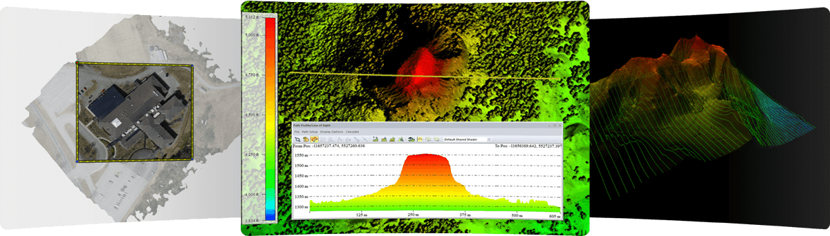
With tools for applying colorful shaders for 2D and 3D data Global Mapper’s dynamic terrain visualization supports imported elevation data imported and TIN layers generated from 3D vector data. Cross-sections profile views of terrain data can be created from any existing or drawn linear feature on the map. Profiles can be used to calculate elevation statistics and slope along a given path and line-of-sight analysis options can be used to visualize any obstructions that may interfere with the view along the path. Combining data views, visualization option allows the Path Profile display to be rendered as a terrain cutaway in the 3D View.
Terrain data can be utilized through various analysis tools to create new layers of vector features highlighting patterns or values present in the terrain data. Any imported or processed elevation layer can be used to generate 3D contour lines in vector format. Options in a contour analysis include customized contour interval spacing, polygon feature generation, and the identification of local peaks and depressions in the loaded terrain layer. Watershed delineation determines the likely linear path of streams and the drainage or catchment areas of those streams. Building from the line-of-sight analysis in the profile view, viewshed calculation identifies the covered, or hidden, areas of terrain in all directions within a specified radius of a user-set transmitter location. Advanced viewshed analysis options include Fresnel Zone determination, signal strength loss over distance, and the inclusion of 3D vector features as possible obstructions in the analysis.
Combining vector features with terrain data opens additional analysis and data creation options with cut-and-fill volume calculations from polygon or linear features, flattened site plan creation, and Relative Elevation Model (REM) generation. Cut and fill calculations can be performed on 2D or 3D vector polygon features or along a line to simulate the digging of a trench. When working with a polygon a flat area of terrain can be created blending seamlessly into the surrounding terrain to simulate a flattened pad or building site. The ability to create Relative Elevation Models (REM) allows users to highlight terrain variation in an area of interest, to help visualize smaller terrain changes that may otherwise be hard to identify.
Many functions in Global Mapper can be performed by initiating a script. Formatted as a simple ASCII file, a script is commonly used to automate repeating or recurring tasks, eliminating the need to manually process the data. The Global Mapper scripting language supports importing, converting, reprojecting, analyzing, calculating attributes, splitting layers, interactively prompting users for files and folders, and exporting all supported data formats.
To streamline a data processing workflow, Global Mapper offers a batch processing function that allows multiple selected files, or all compatible files within a specified folder, to be converted, reprojected, gridded, and renamed without rendering the data in the various viewers.
Version 25.1 release of Global Mapper Standard includes
Learn more about the latest features here.
What version of Global Mapper is best for you?
Compare the Standard and Pro features to find out!
Standard license includes:

All the great features of standard plus...

Global Mapper Suite
Everything you need in GIS software
A comprehensive suite of GIS desktop and mobile applications as well as a software development kit with tools to satisfy the needs of a wide range of workflows.
The all-in-one GIS software
Global Mapper Pro® expands upon the extensive functionality of the standard version of the application for those with advanced workflows. It includes all features available in the standard version plus lidar/point cloud creation, classification, and analysis; advanced image, terrain, and vector editing and analysis; and scripting support for workflow automation.

Geospatial data viewing and collection in the palm of your hand
Global Mapper Mobile® is an iOS and Android application for viewing and collecting GIS data. It’s a perfect complement to the desktop version of Global Mapper, providing maps-in-hand functionality for field data gathering. The Pro version of the application expands on the functionality of the application, with an array of professional-grade tools.
![]()
Advanced GIS Software Development Kit
The Global Mapper Software Development Kit® (SDK) is a toolkit that provides access to much of the functionality of the desktop application from within an existing or custom-built application, allowing in-house developers to create a unique version of the software to meet their specific needs and requirements.
Global Mapper offers a complete set of GIS tools.