Advanced GIS Software Development Kit

VERSION 25.1

The Global Mapper Software Development Kit (SDK) is a toolkit that provides access to much of the functionality of the desktop application from within an existing or custom-built application. The SDK also enables the creation of custom toolbars and extensions to enhance the data processing and analysis functionality of the standard version of Global Mapper. This capability allows in-house developers to create a unique version of the software to meet their specific needs and requirements.
The Global Mapper Software Development Kit (SDK) is available as 32- or 64-bit Windows DLL and can be used with many programming languages on a Windows platform, including Visual C++, Visual Basic, and Visual C#. It also includes a managed .NET wrapper which simplifies the memory management details when using the Global Mapper SDK with Microsoft’s .NET Framework.
The Global Mapper Software Development Kit (SDK) supports a variety of file formats. Its extensive import and export file compatibility ensure that it is one of the most interoperable GIS applications available today in the market.
The Global Mapper SDK provides access to much of the functionality of the desktop application from within an existing or custom-built application.

Spatial Operations
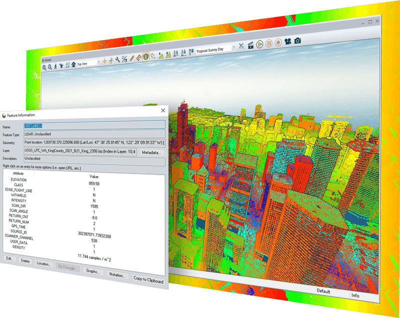
The Global Mapper SDK can be used to load any number of layers from almost all of the formats supported by Global Mapper. This includes nearly all imagery, elevation, and vector data formats. The SDK also supports online WMS sources, including built-in access to NED, SRTM, and Landsat7 sources. It can even load ungeo-referenced imagery by providing ground control points and projection. The toolkit will perform the rectification and display the raster layer in the appropriate projection.
The Global Mapper SDK can be used to initiate a variety of spatial data analysis procedures:
As well as providing access to spatial data files, the Global Mapper SDK offers the option to read and write data stored in a spatial database. Import and export data from:
The Global Mapper SDK provides the ability to display the Global Mapper 3D view with terrain and 3D vector features, along with any other data draped on the terrain surface. It can also retrieve the elevation at any location from elevation layers and it can even perform viewshed analysis using elevation grid layers and 3D vector data (areas, lines, and points). Recent versions have added many significant updates for working with 3D data:
Global Mapper Suite
Everything you need in GIS software
A comprehensive suite of GIS desktop and mobile applications as well as a software development kit with tools to satisfy the needs of a wide range of workflows.
![]()
Trusted by GIS professionals worldwide
Global Mapper® is a cutting-edge GIS software that provides both novice and experienced geospatial professionals with a comprehensive array of spatial data processing tools, with access to an unparalleled variety of data formats.
The all-in-one GIS software
Global Mapper Pro® expands upon the extensive functionality of the standard version of the application for those with advanced workflows. It includes all features available in the standard version plus lidar/point cloud creation, classification, and analysis; advanced image, terrain, and vector editing and analysis; and scripting support for workflow automation.

Geospatial data viewing and collection in the palm of your hand
Global Mapper Mobile® is an iOS and Android application for viewing and collecting GIS data. It’s a perfect complement to the desktop version of Global Mapper, providing maps-in-hand functionality for field data gathering. The Pro version of the application expands on the functionality of the application, with an array of professional-grade tools.
Download a trial of Global Mapper SDK today!

